Comb Ridge - Southeast Utah
Anasazi Ruins and Springtime Deserts
After a pseudo-graduation from the University of Utah and all the pleasures that has provided for the last two years (sarcasm does not apply to the last semester, which between the various animation orientated classes was downright fun), Ann, the dog, and I were able to get down to the southeast corner of Utah to poke around the Anasazi ruins and enjoy the surprisingly lush springtime desert.
Jump directly to the Comb Ridge anasazi ruins photography gallery
Anasazi translates to either "ancient ones" or "ancient enemy," depending on what lexicon you subscribe to, and the cliff and canyonside ruins stand as testament to the lasting impact of human civilization on the environment, long after the native environment won the battle, but lost the war. There are multiple theories for the sudden departure of the Anasazi people from the Four Corner area during the 12th and 13th centuries: drought and famine, war, and cultural change. Almost all are correct, the real reason for the migration to more hospitable environs overdetermined (save for a handy time machine).
For many outdoorsy folks an expedition to explore ruins is purported to be a spiritual experience; for Ann and myself the area serves as an effective warning that a geopolitically isolated society, when faced with changing social and environmental factors, choose to bunker down (quite literally, e.g. kivas) and grow dramatically more socially conservative and religiously fundamental, rather than to wake up and smell the overland traded coffee. Of course for Wally the dog, such a trip signifies the time of the year when it becomes too hot to march around outside.
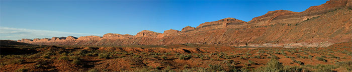 Comb Ridge Panorama, facing north
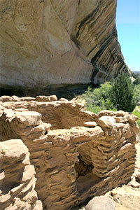
Blanding or Bluff are the departure points for most of the canyons that drain into each side of Comb Ridge, a 30 miles long sandstone bluff that is all but impassible for most of its length. We explored some smaller ruins and hikes around the north end, including Butler Wash ruin and Mule Canyon Overlook ruin (both are accessible from the road) before hiking in to the Mule Canyon towers. A series of five towers, originally at least two stories tall, circle a pouroff marking the beginning of the "full" Mule Canyon. During a rainstorm water would thunder over a series of 30-50 foot drops into the canyon, watched over by the towers. Below, there are a number of ruins on the north side of the canyon walls; these would be the actual living and storage quarters, rather than the more inscrutable towers above the canyon. We hiked down a small crack in the canyon walls to reach some ruins hidden in a small alcove. Down the canyon, more ruins were rendered inaccessible by the breakup of ledges, moki steps, or ladders over the years.
That afternoon, we hiked up Arch Canyon several miles. Arch Canyon is more accessible than some of the canyons we would explore in the days following. At one point, it was a potential inclusion in the Natural Bridges National Monument 20 miles to the west. During the 70's and 80's (judging by Ann's memory) a road up the canyon floor was opened up to allow passenger vehicle travel, resulting in a dusty, dry canyon. Now, only modified Jeep vehicles can traverse the road, Arch Canyon stream flows fairly consistently with deep pools, and towering grass fills the bottom of the canyon. It is still possible to hike to the ruins in the canyon, and although they have been picked clean of artifacts the ruins themselves are in decent shape. About a mile and a half up the canyon a kitchen / armory ruin has many shelf and storage spaces and signs of constant fire.
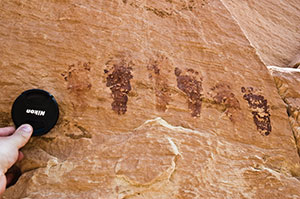
Traveling south along the length of Comb Ridge, the land gradually progresses from desert uplands and canyons to the drier red sand of the San Rafael river valley leading into Monument Valley. On the Butler Wash side of Comb Ridge (east), a side canyon slices into the ridge about every quarter mile. Many of these canyons contain ruins, many in a fairly decent shape with extant kivas, multiple story towers and buildings, and a fair amount of artifacts still to be overturned.
Having overheated the dog, we took a drive through the Valley of the Gods, the Utah extension of Monument Valley geology. Still the red sand soil everywhere, but a generous amount of green plants to compliment the colors. To escape from the heat of the valley, one drives up over 1100 feet of 10% grade cliffside road to reach the mesa that serves as the cooler source for all the canyons below.
Jump directly to the Comb Ridge anasazi ruins photography gallery